Books on world travel and some personal geographies
The holidays are already here or arriving soon. For some, it's an opportunity to grow in sun or shade and wait, doing nothing (lazy ).
For me, it's an opportunity to "get rid of the rest of the year" and immerse myself in books with the same pleasure that I find, sometimes, to dive in warm water and turquoise .
In this connection let me tell you some of my recent reading I have much appreciated and who are current on vacation or when we are preparing to leave. The
Editions Transboréal in partnership with Baladéo (seller accessories for walks) had the good sense to publish a collection for some months dubbed "Little philosophy of travel" . "This collection gives voice to authors who, with respect to heart, are able to bring to him the elements of reflection accompanied by personal experiences. Are addressed both points of view on the trip - the motivations departure, writing - travel modes - walking, train, canoe - both sport - mountain climbing, martial arts - or art - watercolor, photography. " . In this collection, I read and loved two songs that I hope the other titles in the collection are in the image of these two:
- "The call of the road. Little mystic outbound traveler " Sebastian Jalade
- " Poetry of the rail. Little apology train travel " Baptiste Roux.
This title made me think of the documentary series "trains like no other" by François Gall and Bernard d'Abrigeon aired on television since 1991 and that can be found on DVD .
The book "Small collection of landscapes" Pierre Gilloire published by Editions The Surveyor is a little gem of personal geography. It reads the back cover:
"We drive for hours. The road never fails to get anywhere. The floor is increasingly degraded, the modern world is behind us, poles telegraph disappeared. The landscape is made of horizontal bands overlaid each with its grain and color. A soil dominated the plant, an herb whose colors range from lime green to green almond. steppe A horizon from which emerge from the hills isolated. Décor changing ... This morning, the islands floating on a cushion of mist. Time for me to take some pictures, and the steam has dissipated ... Here and there, the mineral takes the advantage, the grass gives way to vast expanses stony as the sun warms throughout the day. The air crackles. It is unclear where this has arisen glittering web that has just appeared. A salt lake shores bleached, or perhaps a mirage? In fact, a perfectly tuned and the other two layers as thin blades, one silver and one blue. Above, the sky is fringed with a few cumulus clouds. Unattainable mirage dissolves like mist in the morning. Lines is treated, the relief is used as softened. A serene landscape, without broken lines, no frills, almost abstract. Nothing moves, except the clouds and their shadows sliding on the ground ... "
By reading these few lines, inevitably there are other writers who have preceded Pierre Gilloire in this kind of personal geographies, and where landscapes and what they can inspire as thought and feeling, above all reveal our relationship to the world: Gracq course, but also Dino Buzatti, Ernst Jünger, Claude Simon, Julian Green, Gil Jouanard Pierre Sansot, and many others.
For lovers of stories travel, the time has perhaps come to read or reread Paul Morand, Nicolas Bouvier, Victor Segalen, JM.G. Le Clezio, Bruce Chatwin, Jack London, Georges Perec, Jean Grenier, Francisco Coloane, Michel Le Bris, all heirs of their ancestors (often travelers) were among others that Herodotus, Gerard de Nerval, Theophile Gautier, Stendhal, Proust, Pierre Loti, Joseph Conrad, Blaise Cendrars, and some poets, jewelers our world view, as Charles Baudelaire, Arthur Rimbaud, Paul Verlaine, Jean Follain, Emile Verhaeren, Leon Paul Fargue Eugene Guillevic, Louis-René des Forêts, Kenneth White, Claude Roy and many others.
Vacation time is, apparently, the time to empty itself. For my part, but rather the time to refuel: reading, travel, meetings. Rimbaud wrote "Real life is elsewhere" . I am often tempted to believe. Geography is first used to travel and cards are the passports of our dreams. Holidays it can also be time set aside cards that invade more and more the Internet, our mobile phones and our GPS to make us draw more cards, those of our steps, guided by the search somewhere else, especially if it is illusory.
"Do you know if we are still far from the sea ? : is the title of a work of poetry by Claude Roy, this could be a constant questioning in our search elsewhere. It seems we always end up returning to the sea ..
Happy holidays and good reading.
Monday, July 6, 2009
Sunday, July 5, 2009
Crystal Meth And Blurred Vision
power images of power in the world
In an article in the section "Essays" Le Monde dated June 2, 2009, David Zerbib reflects the work of WJT Mitchell entitled "Iconology. Image, text, ideology " appeared in the series" Thinking / cross "published " The Prairie "Ordinary .
Mitchell, professor of literature and art history at the University of Chicago, is considered one of the representatives of "visual studies" born in the United States in the 80 to address the images in the humanities, in conjunction with aesthetics or art history, and disclose it look like political construction.
In his book, Mitchell is more interested in the idea of "imaging" as such at the "material identity images" . Lying on the border between image and language, the book Mitchell claims that, contrary to the word, "image is the sign that says no not be a sign that disguises to impersonate (and, in the eyes of the believer, he does so in effect) for a natural immediacy and presence ". The basic question for Mitchell " How to transform t Are the images and imagination that powers the product worthy of belief and respect? ".
Focusing on systems of power and value, that is to say, the ideology that underlies our report images, Mitchell founded a "iconology" (or the science images) which wants a "political psychology icons" but also a "study of the conflict between those who defend the truth images, and those who pourfendent as illusion ". Rejecting the illusion of any proposed suitor " purge the world of his images ", Mitchell asserts the existence of" hypericônes ", that is to say "imaginary representations that shape our ways of knowing ." Continuing his argument, Mitchell says "modern look" based on trust "blind" in images supposed "natural" or scientifically "real ", allowing him to devote himself to the " idol of reason conquering proclaiming the transparency of the real, while is itself ethnocentric ". Mitchell is a keen observer " power relationships that lurk in our eyes ", especially when they rely more and more looks supposedly objective and universal. Mitchell does not propose another model or another faith. He did as a research project that point and reveal the underlying mechanisms of our modern eyes.
Based on the analysis of Mitchell, how not to think about images the world that are the maps and imagery (satellite and aerial) which abounds our world today?
So when Mitchell wrote "It does a table once before how it shows what can be seen ", we can only implement this analysis to images of the world, especially when you see a " coverage imagined " (as defined coverage of images) systematic world that are images of spatial mapping sites online or virtual globes. As is the case in front of a poster, we think watching the satellite pictures while we are in the grip of a powerful performance. The book Mitchell dates from 1986, is an amazing news with "googlomapisation the world", that is to say the setting of world maps and images from Google. The cards, but most of the space images Google (and everyone else), give to see the world through pictures that claim to total objectivity when these images are constructed from our contemporary perspective on the world. News programs, documentaries, films, commercials, and even replicated in the field of writing novels and comics, these images take ownership of the world and we require more and more as the only possible scientific and objective picture of real world, in a sort of "enterprise iconological totalizing" . Every image carries an ideology and therefore an attempt to seize power over the way these images. It is not about a stance a bit simplistic denunciation of "Big Brother is watching you" of 1984 George Orwell, but only to identify what lies behind the images of the world in terms of power over the world and individuals to whom these images are increasingly presented to point towards a risk of "visual saturation" of our views on the world. To see the world too, we may be unable to discern neither observe. 
In an article in the section "Essays" Le Monde dated June 2, 2009, David Zerbib reflects the work of WJT Mitchell entitled "Iconology. Image, text, ideology " appeared in the series" Thinking / cross "published " The Prairie "Ordinary .
Mitchell, professor of literature and art history at the University of Chicago, is considered one of the representatives of "visual studies" born in the United States in the 80 to address the images in the humanities, in conjunction with aesthetics or art history, and disclose it look like political construction.
In his book, Mitchell is more interested in the idea of "imaging" as such at the "material identity images" . Lying on the border between image and language, the book Mitchell claims that, contrary to the word, "image is the sign that says no not be a sign that disguises to impersonate (and, in the eyes of the believer, he does so in effect) for a natural immediacy and presence ". The basic question for Mitchell " How to transform t Are the images and imagination that powers the product worthy of belief and respect? ".
Focusing on systems of power and value, that is to say, the ideology that underlies our report images, Mitchell founded a "iconology" (or the science images) which wants a "political psychology icons" but also a "study of the conflict between those who defend the truth images, and those who pourfendent as illusion ". Rejecting the illusion of any proposed suitor " purge the world of his images ", Mitchell asserts the existence of" hypericônes ", that is to say "imaginary representations that shape our ways of knowing ." Continuing his argument, Mitchell says "modern look" based on trust "blind" in images supposed "natural" or scientifically "real ", allowing him to devote himself to the " idol of reason conquering proclaiming the transparency of the real, while is itself ethnocentric ". Mitchell is a keen observer " power relationships that lurk in our eyes ", especially when they rely more and more looks supposedly objective and universal. Mitchell does not propose another model or another faith. He did as a research project that point and reveal the underlying mechanisms of our modern eyes.
Based on the analysis of Mitchell, how not to think about images the world that are the maps and imagery (satellite and aerial) which abounds our world today?
So when Mitchell wrote "It does a table once before how it shows what can be seen ", we can only implement this analysis to images of the world, especially when you see a " coverage imagined " (as defined coverage of images) systematic world that are images of spatial mapping sites online or virtual globes. As is the case in front of a poster, we think watching the satellite pictures while we are in the grip of a powerful performance. The book Mitchell dates from 1986, is an amazing news with "googlomapisation the world", that is to say the setting of world maps and images from Google. The cards, but most of the space images Google (and everyone else), give to see the world through pictures that claim to total objectivity when these images are constructed from our contemporary perspective on the world. News programs, documentaries, films, commercials, and even replicated in the field of writing novels and comics, these images take ownership of the world and we require more and more as the only possible scientific and objective picture of real world, in a sort of "enterprise iconological totalizing" . Every image carries an ideology and therefore an attempt to seize power over the way these images. It is not about a stance a bit simplistic denunciation of "Big Brother is watching you" of 1984 George Orwell, but only to identify what lies behind the images of the world in terms of power over the world and individuals to whom these images are increasingly presented to point towards a risk of "visual saturation" of our views on the world. To see the world too, we may be unable to discern neither observe.
Saturday, July 4, 2009
Is Protek Chemical A Scam Job
mapping radar and traffic accidents
To celebrate the first weekend of great holiday departures, the Road Safety expecting a massive influx of motorists on the roads of France.
For several years the number killed and injured in road transport continues to decline. How can we not rejoice? For specialists, this is certainly due, in large part, to the strengthening of political control by speed cameras that have flourished along the roads, particularly since the early 2000s.
The speed cameras are already well mapped, either on websites or in GPS in-vehicle navigation aid road. The Road Safety itself provides all the information about speed cameras and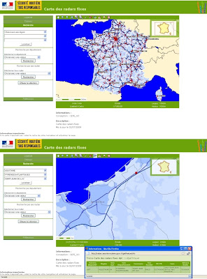
The Road Safety also provides information on the distribution of radar mobile departments. But it is not enough information to motorists themselves because the location of mobile cameras or temporary is not indicated.
Yesterday I saw on TV a story about warning systems and mapping called "collaborative" of traffic radar, designed to complement the information already available on the fixed cameras, information delivered by a "time Real "by motorists for mobile radars or temporary.
Thus, the system AlerteGPS offers motorists equipped with this system to send a warning to other motorists to alert them to any temporary or mobile radar. Immediately reported a radar, this information is broadcast via satellite or GPRS / UMTS to the databases of the device and then immediately rerun in near real time to all other motorists equipped with the same GPS system. They see then see a warning on their GPS equipment when they are near the camera and reported. But adding a new radar can also be done from the website of the company whose here here the result in the map interface:
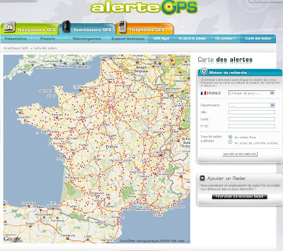
Another GPS, Coyote , offers a similar device called Coyote Mini :

This system, that is "the only alarm GPS of fixed and mobile radars "(voire. ..) works as a subscription. It also allows motorists who are equipped to report any temporary or mobile radar and disseminate this information in near real time by GSM to other motorists equipped with the same device and who have paid their subscription. The site
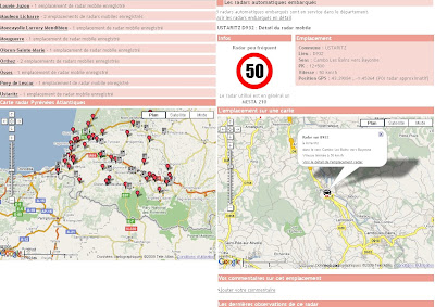
Radar mobiles.fr offers also a mapping of fixed and mobile radars based on Goole Maps that allows you to search by department, road and municipality. "The information contained on the site are either from a location on the ground or a ticket received by a user. You too can participate and enrich the database by submitting your sites with the category Add."
On 30 June, the City of Mazamet in the Tarn, organized the operation "12,000 lights for 12,000 lives saved on the road" . It aimed to highlight the achievements in road safety including reducing the number of deaths. On May 17, 1973, the same city Mazamet had hit the headlines with the operation "Mazamet wiped off the map" , organized with the Road Safety. During this operation , thousands of people grew long in the streets of the city. Last year, 16,170 people were killed on the roads and the people of this era Mazamet had 16 171 inhabitants. For fifteen minutes, people were lying Mazamet, silent and motionless, to illustrate the carnage. This was the launch of two slogans become Famous: "belt for life" and "driving, the sight that's life" .

(Copyright Road Safety)
can be found on the site of the INA some pictures of this in the show crossfire of September 26, 1973:
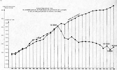
following years The number of dead had begun almost steady decrease as shown in this graph the annual number of fatalities in road accidents on the national network, available here on the site of Road Safety:
( Source Road Safety)
I tried to picture what had otherwise been in operation from 1973 Mazamet using the little guy from Google Maps, Pegman, and the representative of a reason to lie for 100 killed road at the time.
Today in France, the annual number of fatalities road approximately 4,200 people, or 12,000 lives saved since 1973, hence the operation Mazamet of 30 June. This is another way of representing the results, always keeping in image for the City of Mazamet which, seen from the sky might look like this, using the same Pegman, but standing this time, to symbolize the lives saved (a Pegman for 100 lives saved).
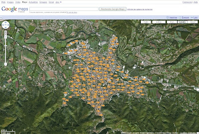
The Prefecture de Police de Paris has developed a mapping of accident cumulative (2006/2007/2008) of the Capital districts and for beltway.
This online mapping can also discover the intersections and sections of track the most accident.

(Copyright Prefecture de Police de Paris)
There are many other maps Internet of accident of French roads. Information exists and is now increasingly well known, especially in map form.
If you take the road today, but especially good holiday beware! 
To celebrate the first weekend of great holiday departures, the Road Safety expecting a massive influx of motorists on the roads of France.
For several years the number killed and injured in road transport continues to decline. How can we not rejoice? For specialists, this is certainly due, in large part, to the strengthening of political control by speed cameras that have flourished along the roads, particularly since the early 2000s.
The speed cameras are already well mapped, either on websites or in GPS in-vehicle navigation aid road. The Road Safety itself provides all the information about speed cameras and

The Road Safety also provides information on the distribution of radar mobile departments. But it is not enough information to motorists themselves because the location of mobile cameras or temporary is not indicated.
Yesterday I saw on TV a story about warning systems and mapping called "collaborative" of traffic radar, designed to complement the information already available on the fixed cameras, information delivered by a "time Real "by motorists for mobile radars or temporary.
Thus, the system AlerteGPS offers motorists equipped with this system to send a warning to other motorists to alert them to any temporary or mobile radar. Immediately reported a radar, this information is broadcast via satellite or GPRS / UMTS to the databases of the device and then immediately rerun in near real time to all other motorists equipped with the same GPS system. They see then see a warning on their GPS equipment when they are near the camera and reported. But adding a new radar can also be done from the website of the company whose here here the result in the map interface:

Another GPS, Coyote , offers a similar device called Coyote Mini :

This system, that is "the only alarm GPS of fixed and mobile radars "(voire. ..) works as a subscription. It also allows motorists who are equipped to report any temporary or mobile radar and disseminate this information in near real time by GSM to other motorists equipped with the same device and who have paid their subscription. The site
Radar mobiles.fr offers also a mapping of fixed and mobile radars based on Goole Maps that allows you to search by department, road and municipality. "The information contained on the site are either from a location on the ground or a ticket received by a user. You too can participate and enrich the database by submitting your sites with the category Add."

On 30 June, the City of Mazamet in the Tarn, organized the operation "12,000 lights for 12,000 lives saved on the road" . It aimed to highlight the achievements in road safety including reducing the number of deaths. On May 17, 1973, the same city Mazamet had hit the headlines with the operation "Mazamet wiped off the map" , organized with the Road Safety. During this operation , thousands of people grew long in the streets of the city. Last year, 16,170 people were killed on the roads and the people of this era Mazamet had 16 171 inhabitants. For fifteen minutes, people were lying Mazamet, silent and motionless, to illustrate the carnage. This was the launch of two slogans become Famous: "belt for life" and "driving, the sight that's life" .

(Copyright Road Safety)
can be found on the site of the INA some pictures of this in the show crossfire of September 26, 1973:
following years The number of dead had begun almost steady decrease as shown in this graph the annual number of fatalities in road accidents on the national network, available here on the site of Road Safety:
( Source Road Safety)
I tried to picture what had otherwise been in operation from 1973 Mazamet using the little guy from Google Maps, Pegman, and the representative of a reason to lie for 100 killed road at the time.

Today in France, the annual number of fatalities road approximately 4,200 people, or 12,000 lives saved since 1973, hence the operation Mazamet of 30 June. This is another way of representing the results, always keeping in image for the City of Mazamet which, seen from the sky might look like this, using the same Pegman, but standing this time, to symbolize the lives saved (a Pegman for 100 lives saved).

The Prefecture de Police de Paris has developed a mapping of accident cumulative (2006/2007/2008) of the Capital districts and for beltway.
This online mapping can also discover the intersections and sections of track the most accident.

(Copyright Prefecture de Police de Paris)
There are many other maps Internet of accident of French roads. Information exists and is now increasingly well known, especially in map form.
If you take the road today, but especially good holiday beware!
Thursday, July 2, 2009
Does Open Hole Knee Braces Work
Similar Images of Google Labs
World Géonumérique On his blog, Thierry Joliveau recently presented here results on keywords and names related geomatics tool from Google Trends Google. Google Trends analyzes the frequency before a keyword into the Google search engine and provides statistical results chronological and geographical such as graphs. This tool is part of those developed in Google Labs . I've done some tests show the great variation in results by spelling words entered, which does not mean that the tool is fully discredit.
It is another tool of Google Labs, which interested me was Similar Images .
Better too long an explanation, here is the video presentation of one of the project at Google Similar Images:
Similar Images lets you search more images using image content themselves that the words associated with images. As its name suggests, focuses Similar Images find similarities in the images. Google talk instead of using "visual similarity". Following a query, a results page is displayed as one can get with the feature "classic" image search "Google.
The first example below shows the results obtained with Similar images for the keyword "France Map"

We can compare this result with that obtained with the tool "classic" "Search Images "Google:

Like the classic image search in Google, the query results are displayed as thumbnail images. It is then possible, from the menus provided for this purpose at the top of the page, select only the images of a certain size (small, medium, large, very large) or corresponding to a certain type of content (news, faces, clip art, line drawing, photo content), or by dominant color among 12 colors available. The major advantage of
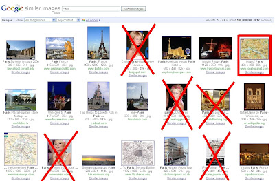
Similar Images is to propose some thumbnails of the results obtained by the query, a link "Similar Images" . This link provides access to images considered similar, which also appear in the top banner after clicking a thumbnail. This feature can be very helpful to sort among the immediate results of his first complaint. Thus, in the example below the results appear to "Paris" after selecting only images of maps of Paris suggested by the link "Similar Images":

This avoids, in particular, fall images of ... Paris Hilton ...
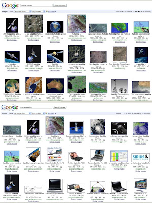
But just like Google Trends Similar Images is very sensitive to spelling or the order of the keywords entered. Thus, in the example below, depending on whether one takes "satellite images" (above) or "satellite images" (bottom), results may differ materially.
Many other applications are looking for content, either on audio, video, text, etc.. eg TinEye or Voxalead . Google was not the exclusivity of this kind of functionality, but we know the "strike force" of the Mountain View company when she decided to pursue investment significant research and development.
Finally, how can we not question the quality and relevance of results obtained with "Similar Images" when searching for "pictures like" Michael Jackson, the man whose face image does ceased to change throughout his life ... 
World Géonumérique On his blog, Thierry Joliveau recently presented here results on keywords and names related geomatics tool from Google Trends Google. Google Trends analyzes the frequency before a keyword into the Google search engine and provides statistical results chronological and geographical such as graphs. This tool is part of those developed in Google Labs . I've done some tests show the great variation in results by spelling words entered, which does not mean that the tool is fully discredit.
It is another tool of Google Labs, which interested me was Similar Images .
Better too long an explanation, here is the video presentation of one of the project at Google Similar Images:
Similar Images lets you search more images using image content themselves that the words associated with images. As its name suggests, focuses Similar Images find similarities in the images. Google talk instead of using "visual similarity". Following a query, a results page is displayed as one can get with the feature "classic" image search "Google.
The first example below shows the results obtained with Similar images for the keyword "France Map"

We can compare this result with that obtained with the tool "classic" "Search Images "Google:

Like the classic image search in Google, the query results are displayed as thumbnail images. It is then possible, from the menus provided for this purpose at the top of the page, select only the images of a certain size (small, medium, large, very large) or corresponding to a certain type of content (news, faces, clip art, line drawing, photo content), or by dominant color among 12 colors available. The major advantage of
Similar Images is to propose some thumbnails of the results obtained by the query, a link "Similar Images" . This link provides access to images considered similar, which also appear in the top banner after clicking a thumbnail. This feature can be very helpful to sort among the immediate results of his first complaint. Thus, in the example below the results appear to "Paris" after selecting only images of maps of Paris suggested by the link "Similar Images":

This avoids, in particular, fall images of ... Paris Hilton ...

But just like Google Trends Similar Images is very sensitive to spelling or the order of the keywords entered. Thus, in the example below, depending on whether one takes "satellite images" (above) or "satellite images" (bottom), results may differ materially.

Many other applications are looking for content, either on audio, video, text, etc.. eg TinEye or Voxalead . Google was not the exclusivity of this kind of functionality, but we know the "strike force" of the Mountain View company when she decided to pursue investment significant research and development.
Finally, how can we not question the quality and relevance of results obtained with "Similar Images" when searching for "pictures like" Michael Jackson, the man whose face image does ceased to change throughout his life ...
Wednesday, July 1, 2009
Women Weting Themsleves
Georeferencing of cultural heritage in France
To celebrate its 50 years, the Ministry of Culture has given the company Hyptique (which has, in the other CD-Roms "Land of Cities" published by Belin and which I recently here talked ) a website dedicated to this event .
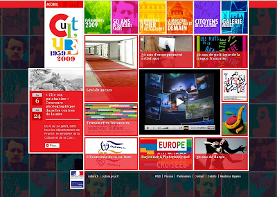
(Copyright Ministry of Culture)
Rubric "Citizens of Culture can find a map of France, using Google Maps, which locates photographs of many places and events illustrating the wealth national cultural in many forms.
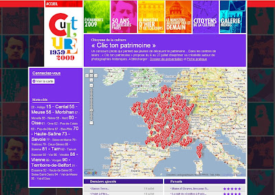
(Copyright Ministry of Culture)
By clicking on each icon, one can see a photograph and explanatory text. I had the privilege to participate in the testing phase of this section and deposit some contributions including one on House of Pierre Loti in Rochefort which I mentioned here .
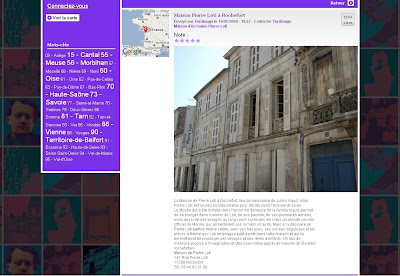
(Copyright Ministry of Culture)
Originally designed to allow any user to file its own pictures and comments on these places of cultural heritage, the Ministry of Culture has returned to a less "participatory "This section would have allowed the spontaneous georeferencing of much of" heritage "French but with problems of definition and right images and their objects, not to mention the tremendous work of moderate contributions may be underestimated initially. Finally the Ministry of Culture has decided to limit this to a heritage map operation called "Click your heritage" . This is a photo contest organized in partnership with the High Committee for youth between 6 and 24 July, which should enable young people attending the summer recreation centers to learn about photography. "Designed by Francoise Denoyelle, professor at the Institut Louis-Lumière, the contest will take participants to set up a photographic inspired by those of Christmas The Boyer and Georges Arlaud which, in the twentieth century, have traveled France with their device. This new photographic body born of the competition will be paid at the Library of Architecture and Heritage in the European Heritage Days 19 and 20 September. ".
already exist to other sites of the Ministry of Culture which can discover the cultural heritage through an inlet or geographical mapping from databases developed over the years such as the base Mérimée.
This site "Architecture and Heritage" to discover the outcome of the heritage inventory cultural, historic monuments, and library of Architecture and Heritage . The site
"Architecture and Heritage" provides access to geographical data from the Inventory of heritage whose geographical basis of the work is across the township. "Investigations into the field by the researchers in charge of the inventory are grouped within a department, then by all township buildings or objects, then by individual work folders" . .
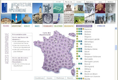
(Copyright Ministry of Culture)
Data access is done by departments and municipalities for which there is an indication of the nature of the data available and searchable online.

(Copyright Ministry of Culture)
Clicking on old photographs available online you can discover not only the photographic heritage but also find images of places or landmarks that still exist today or and can then compare to current views, whether his own photographs, those of others available in Panoramio, or with images or aerial views ground available in the various mapping sites online.

(Top View Theatre of Bayonne and the Adour early twentieth century, Copyright Ministry of Culture, Media architecture and heritage - Diffusion NMR. Bottom view taken by me Christmas in 2007 during the Bayonne)
course, these few examples shown do not claim completeness of the present achievements and current projects of the Ministry of Culture in mapping and georeferencing of cultural heritage. In addition, the Ministry of Culture is not the only player in the French cultural heritage, since local authorities, associations, and numerous institutions working for the protection and enhancement of cultural heritage, a valuation that now happening more and more by an Internet presence, including by geographical discovery and mapping. 
To celebrate its 50 years, the Ministry of Culture has given the company Hyptique (which has, in the other CD-Roms "Land of Cities" published by Belin and which I recently here talked ) a website dedicated to this event .

(Copyright Ministry of Culture)
Rubric "Citizens of Culture can find a map of France, using Google Maps, which locates photographs of many places and events illustrating the wealth national cultural in many forms.

(Copyright Ministry of Culture)
By clicking on each icon, one can see a photograph and explanatory text. I had the privilege to participate in the testing phase of this section and deposit some contributions including one on House of Pierre Loti in Rochefort which I mentioned here .

(Copyright Ministry of Culture)
Originally designed to allow any user to file its own pictures and comments on these places of cultural heritage, the Ministry of Culture has returned to a less "participatory "This section would have allowed the spontaneous georeferencing of much of" heritage "French but with problems of definition and right images and their objects, not to mention the tremendous work of moderate contributions may be underestimated initially. Finally the Ministry of Culture has decided to limit this to a heritage map operation called "Click your heritage" . This is a photo contest organized in partnership with the High Committee for youth between 6 and 24 July, which should enable young people attending the summer recreation centers to learn about photography. "Designed by Francoise Denoyelle, professor at the Institut Louis-Lumière, the contest will take participants to set up a photographic inspired by those of Christmas The Boyer and Georges Arlaud which, in the twentieth century, have traveled France with their device. This new photographic body born of the competition will be paid at the Library of Architecture and Heritage in the European Heritage Days 19 and 20 September. ".
already exist to other sites of the Ministry of Culture which can discover the cultural heritage through an inlet or geographical mapping from databases developed over the years such as the base Mérimée.
This site "Architecture and Heritage" to discover the outcome of the heritage inventory cultural, historic monuments, and library of Architecture and Heritage . The site
"Architecture and Heritage" provides access to geographical data from the Inventory of heritage whose geographical basis of the work is across the township. "Investigations into the field by the researchers in charge of the inventory are grouped within a department, then by all township buildings or objects, then by individual work folders" . .

(Copyright Ministry of Culture)
Data access is done by departments and municipalities for which there is an indication of the nature of the data available and searchable online.

(Copyright Ministry of Culture)
Clicking on old photographs available online you can discover not only the photographic heritage but also find images of places or landmarks that still exist today or and can then compare to current views, whether his own photographs, those of others available in Panoramio, or with images or aerial views ground available in the various mapping sites online.

(Top View Theatre of Bayonne and the Adour early twentieth century, Copyright Ministry of Culture, Media architecture and heritage - Diffusion NMR. Bottom view taken by me Christmas in 2007 during the Bayonne)
course, these few examples shown do not claim completeness of the present achievements and current projects of the Ministry of Culture in mapping and georeferencing of cultural heritage. In addition, the Ministry of Culture is not the only player in the French cultural heritage, since local authorities, associations, and numerous institutions working for the protection and enhancement of cultural heritage, a valuation that now happening more and more by an Internet presence, including by geographical discovery and mapping.
Subscribe to:
Posts (Atom)